- 01 Pax USD 1545 pp
- 02 to 05 Pax USD 1450 pp
- 06 to 10 Pax USD 1325 pp
- 11 to 15 Pax USD 1175 pp
Overview
Annapurna Circuit Trek:
Explore the majesty of the Annapurna in a way that Sir Edmund Hillary had never been able to do.
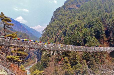
Annapurna Circuit trek circles you around the gorgeous Annapurna massif, in the anticlockwise direction, through the classic trails overlooking the extensive views of lush hills, deep valleys, raging rivers, serene monasteries, colorful Chortens, vibrant Mani walls, dangling suspension bridges, unwinnable Himalayan vistas. This trek is the best possible way to completely explore the charm of Annapurna and its other neighboring pinnacles.
Back in the days before 2000, the trail around the Annapurna circuit was completely natural and off-the-beaten. Many people explored the beauty of Annapurna on foot, and this trek was considered one of the best trekking trails in the world. However, after 2008, the government roadways planned to gravel the classic routes and, consequently, made this trek infamous. Not until the New Annapurna Trekking Trail (NATT) was marked by a few explorers that the trekkers regained an opportunity to enjoy the same classic views without even approaching the dusty roadways, except at some points. The name of the trail has now been transformed into Natural Annapurna Trekking Trails (NATT) as the trails are no longer new.
Planning:
The trek to Annapurna Circuit includes difficult terrain with inclinations and declines. Spend some time getting ready physically for a smoother encounter. Start a fitness regimen a few weeks before your vacation, including aerobic exercises, weightlifting, and simulated treks to increase endurance. Additionally, this aids with acclimatization, a crucial component of your climb that will help you prevent altitude sickness. Create rest days into your schedule so that your body can gradually adjust to higher altitudes. Understand the signs of altitude sickness, and be ready to descend if required.
In a similar vein, thoughtful packing is essential for a pleasant walk. Pack layers of warm clothes as well as rain gear to prepare for different weather scenarios. Make sure you have the necessary equipment, including strong, comfortable hiking boots, a sleeping bag, trekking poles, and a rucksack that is well-organized. Maintain a small, well-equipped pack.
Best time to do Annapurna Circuit Trek?
The best time to trek to Annapurna Circuit Trek is frequently said to be in the spring, from March to May. You may enjoy expansive views of the Annapurna mountain range and neighboring peaks throughout the spring because of the great visibility that the season offers. The weather is often mild and pleasant at lower elevations, with daily temperatures averaging between 15°C and 20°C (59°F and 68°F).
Autumn (September to November) is a great time of year to go to Annapurna Base Camp and is very well-liked by trekkers. Similar to spring, autumn features a brilliant sky that is ideal for admiring breathtaking mountain landscapes. Daytime temperatures range from 15°C to 20°C (59°F to 68°F) at lower altitudes, allowing for comfortable trekking conditions.
Summer (June, July, and August) and monsoon seasons are not advised for the Annapurna Circuit Trek. The ordinary trekker cannot tolerate the bitter cold of winter (December, January, and February).
Food and Accommodations:
In renowned trekking destinations in Nepal like the Annapurna Circuit, food, and lodging are essential components. Teahouses or guesthouses are your main options for accommodation throughout your trip. These mountain refuges provide practical and cozy twin-sharing rooms with all the essentials, including mattresses and blankets. Electric blankets are often provided for additional warmth, which is a welcome relief during the chilly evenings at higher elevations. Teahouses offer a wide variety of food options that are catered to the varied dietary needs of trekkers. Eggs, pancakes, porridge, and Tibetan bread are common breakfast choices. They are accompanied by a variety of hot drinks, including masala chai and hot lemon, which provide a break from the chilly surroundings.
It is always advisable to consult your guide for food recommendations for a more healthy and hygienic option.
Transportation:
Our voyage generally begins in Kathmandu, Nepal's capital. We will take a bus or a private car to Besisahar, which is the Lamjung District's district headquarters and the beginning point for hikes in the Annapurna range. The journey from Kathmandu to Besisahar takes about 6-8 hours.
We will continue our journey after arriving in Besisahar by taking a local jeep or another mode of transportation to the village of Dharapani. The Manang is the region's final road-accessible settlement. You will, however, begin your walk on foot from Dharapani to Chame and then proceed to the goal.
When you reach Gandhruk, you may take a vehicle back to Pokhara and then another tourist bus back to Kathmandu.
Necessary Permits & TIMS:
The Annapurna Base Camp walk necessitates the acquisition of certain licenses, including as the Annapurna Conservation Area Permit (ACAP) and the Trekkers' Information Management System (TIMS) card. These licenses are necessary for controlling trekking activities and assisting with conservation initiatives in the area.
1. Annapurna Conservation Area Permit (ACAP):
To visit the Annapurna area you must get an Annapurna Conservation Area Permit (ACAP). This protected area, noted for its breathtaking natural beauty, varied landscapes, and rich cultural history, is one of the most well-liked hiking areas in the nation.
Cost: Nrs 3000 per person

2. Trekker's Information Management System(TIMS):
For hikers in Nepal, the TIMS (Trekker's Information Management System) card is a necessary piece of identification. It was put into place to improve trekkers' safety and security while also assisting authorities in keeping track of travelers in various hiking locations.
Cost: Nrs 3000 per person for non SAARC tourists and Nrs 1000 for SAARC trekers.
Necessary documents for Permits:
You will only need your valid passport photocopy(validity of 6 months).
Highlights
- Experience rich culture.
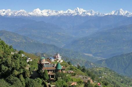
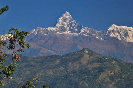
- Stunning Mountain Views of Annapurna I, II, III, and IV, Gangapurna, Nilgiri, Tarke Kang, Lamjung Himal, and other mountains.
- Walk through one of the highest walkable mountain passes in the world, Thorong La.
Itinerary
As your plane descends into Kathmandu, the views of the entire valley appear intoxicating. Following the visa procedure, you will see one of our representatives, waiting for you at the exit point of the airport, carrying a play card of your name in his hand.
He will welcome you in a traditional Nepalese style with a fresh garland, a warm smile, and a hospitable Namaste. Then, through the winding alleys of Kathmandu, he will guide you to your hotel and help you accommodate in a new environment.
In the evening, you will be introduced to your guide, who will be accompanying you in all the odds and evens during the trek.
From Kathmandu, we will catch the earliest possible bus to Besisahar so as to reach there in late noon. This bus ride will contour you around the hilly highways, guarded by the high hillocks and pastoral fields, just to introduce you to the serenity of Besisahar.
Once we get there, we will hire a local Jeep to Jagat which will drive us along the newly paved dusty road of Annapurna. Despite that, the views are sensational with a gorgeous range of the Annapurna showcasing its glamour at its fullest. At Jagat, there is not much to see except a small hot spring pool on the riverside. But, this is enough to trigger your expectations for more future surprises.
Early in the morning, we will leave Jagat and head on towards our next station Bagarchap which appears to be very far on the map. It is a strenuous day as the ups and downs are quite very frequent.
Within about 2 hours of trekking, we will encounter a beautiful waterfall at Chamje. Then, through the off-the-beaten NATT (Natural Annapurna Trekking Trails) trails, we will open up into a calm-looking village of Tal which creates an incredible setting for a perfect natural photo shoot. It feels quite amazing to be there.
After that, we will walk along the stony lane which is carved out of the rocky wall. The suspension bridge, hanging over the never-ending depth of the river valley, carves our way out into a village named Dharapani. Within a few minutes of walking, we will expose ourselves to Bagarchap, where there are nice lodges to stay. There is also a monastery if you would like to engage in a spiritual ambiance.
From Bagarchap, an hour of steep ascend will lead us to a village named Temang. Through the pristine forest, we will cross a suspension bridge to make an appearance at Thanchowk (Thanchouk). It is a beautiful hamlet, built on a ridge, overlooking the gorgeous panorama of the mountains.
From there, we will join the main trail to the village of Koto, dotted with traditional wooden houses- mostly two-story. Chame is just 30 minutes away by foot from there. Upon arriving at Chame, we will have quick snacks and then, catch a jeep to Pisang- our next stopover. Jeep will take us up to Lower Pisang only, so we will have to walk for a few minutes until Upper Pisang as it is a nice place to stay with clear views of the Annapurna II, III, and IV.
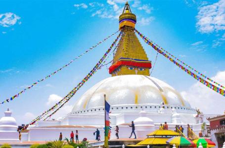
From the Upper Pisang, we will proceed towards the Gyaru through the colorful Chortens and prayer wheels of Buddhist. As we approach Ngawal, the alpine vegetations begin to show off, with barley and buckwheat fields fencing the trail. Then, an array of Mani walls directs us towards a big Stupa (monastery) where the aroma of pine trees enhances the excitement of the trip.
Instead of continuing along the dirt road from Ngawal, we will take the longer route along with the Lophelling monastery that offers better views of nature. As you climb you will notice several old monasteries on the plateau side of the trail. Continuing in the direction of Marshyangdi, we will cross Julu just to make an appearance at the beautiful village of Braka. It is only a couple of Kilometers slog to Manang.
[Braka (aka Braga) is a rewarding place as there are Buddhist monasteries (Gompas) adorned with exquisite statues of Buddha and traditional paintings. Plus, a number of side trips dissociate from there.]
Manang is absolutely a perfect acclimatization spot. The average temperature of Manang is moderate as the spring/autumn days are usually sunny. Plus, a number of side trips could be attempted from Manang.
From Manang, we can take a side trip to the Praken Gompa which overlooks upon the mountains of Annapurna and Tilicho ranges. The vertically soaring Gangapurna glacier also appears distinct at this point. It is so surreal.
If we hadn’t managed to pay a visit to the Braka Gompa then, we should not miss it on this day as this monastery is worth visiting hundreds of times. We may as well hike to the icy lake, but the trail will demand you to put more effort. In the end, we will return to Manang.
It is a pleasant yet strenuous day of trekking in the Annapurna circuit. As we walk through the village of Manang, the big white Gompa appears distinct on the hill. The alpine trees of pine and birch are dotted through the hilly sections from upper Manang to Yak Kharka. We will continue our slog through the villages of Gunsang and Khangsar before making an appearance at the Yak Kharka.
It is a further 40-minute hike to Churi Ledar. If you are going well with the altitude then, it is better to approach Churi Ledar on the very same day. Otherwise, you may as well choose to stay in Yak Kharka.
Wake up early in the morning and leave Chuli Ledar towards the Thorong Phedi. There are few suspension bridges, spanning across the vast riverbeds and valleys, offering views of the rocky faces of the hills.
While on the trail, you must be very careful of the falling stones as there are chances of being hit by them. Recently, ACAP has built stone walls to prevent trekkers and porters from being hit by those stones. Nevertheless, you must be wary of the dangers while trekking to Thorong Phedi. There are also a few good monasteries to pay a visit to during the day.
On this day, it is better not to cross the Thorong La pass because of the icy winds, blowing over the pass, that resists our effort of moving forward.
Before the sun lights up in the sky, we will get our backpacks ready and hit on our journey to conquer this legendary pass. The excitement of stepping into the highest altitude sections of the Annapurna Circuit will have been flowing in our blood prior to departure from the village of Thorong Phedi.
Thorong La Pass, as it sounds, is not really a mountain that you will have to battle with. It is indeed just a flat pass, squeezed between the two mountains, which used to serve as the trading route in the past. Standing on top of this pass gives clear views of the Dhaulagiri peaks and many other indistinguishable ranges. It is indeed a surreal viewpoint.
From there, we will walk across the seemingly desert terrain to Muktinath, which is one of the most revered pilgrimage sites for the Hindus, with a man-sized golden statue of Lord Vishnu inside the main temple.
From Muktinath, we will ascend to the village of Ranipauwa, where a colorful Buddhist monastery shows our way to Lubra (Lupra). Crossing the great Lupra Pass will bring us to the village of Lubra. We will go past the long suspension bridge just to enter into the picturesque village of Jharkot.
It is best to spend a few moments at Jharkot if you are interested in gaining the cultural insight of the Himalayan people. The people of this region have strictly adhered to their historical rituals and traditions, so you can expect to learn something new from this village.
Once we arrive at Jomsom, we must not miss its market place which displays a wide collection of historical and cultural elements. There are a few souvenir stalls that have kept an array of souvenirs for sale. It is worth strolling in this region.
The trail from Jomsom leads towards the Kalopani through the Tukuche Health post. At this point, the view of the Tukuche Peak dominates the western skyline while Nilgiri and Dhaulagiri glitter on the eastern skyline. It feels so amazing to trek along this region.
On the map, you might be tempted to see how such a long distance could be carried on in one day. However, most of the trail is descending so you will arrive at Kalopani easily without much endeavor.
Finally, our next stop is Tatopani, which literally translates to “Hot Water”. As its name suggests, there is a natural hot water spring at Tatopani. The water of this spring is believed to have a natural healing capacity so visitors are in queues most of the time. You may as well plunge into this divine water.
Walk along the newly developed NATT trail that passes through the quaint settlements of the indigenous people of the Annapurna. It is worth turning around a few times as the views grow sensational at this point. You will have to walk along the dirt road for a while just before arriving at Tatopani, but rest of the walks are fabulous.
From Tatopani, it is a long day to Ghorepani. Although descending is an easy task relative to ascending, it is still going to leave your leg unconscious after long descending hours. The trek to Ghorepani from Tatopani is quite a similar case.
The landscapes and the terrain appear to be changing gradually as you proceed to Ghorepani. The alpine vegetation is almost completely replaced by the tropical and sub-tropical woods. During the walk to Ghorepani, it is better to hold on to the villages and stumble across their culture. Most of the houses, that our eyes meet, are painted in red which is a typical Nepali Hill.
Past through the rivers and several ethnic settlements of the Annapurna region before making an appearance at Ghorepani. The word Ghorepani literally translates to “water for the horses”. At the inner hamlets of Ghorepani, you might as well encounter the horses left grazing in the open meadows. It is a wonderful place to stay with clear views of the Annapurna and Machhapuchre peak.
Instead of descending to Birethanti directly, we will travel east towards the Tadapani to reward ourselves with the exquisite views of the great Himalayan ranges. The views from the Tadapani are believed to be quite similar to what seen from the Poonhill, a unique hill station. At Tadapani, you may enroll in the beautiful talks with the grandmas and grandpas. They will help you know about their cultures and traditions in detail.
Ghandruk is just a couple of Kilometers east of Tadapani. It is a Gurung community full of amazing people. They are very much hospitable by nature and are eager to share their golden history to anyone who truly appreciates it. Gurungs are one of the brave ethnic clans of Nepal, who served the British Military during the world war. Because of their bravery, they received many awards and medals from the Queen of Britain.
Besides, their rich culture of respect and love is inspirational. They are kind to everybody and this is what makes Ghandruk a really amazing place to stay.
From Ghandruk, catch a drive to Nayapul via a Jeep and then get a drive down to Pokhara. After all, the strenuous trekking days are over.
On this day, we will stroll around the amazing city of Pokhara. It is a natural hub with pristine waterfalls and serene lakes purifying the air of Pokhara all the time.
We will pay a visit to the World Peace Stupa, which is perched on top of the hill. This stupa is formed of 2 tiers: while the first tier is permitted to monks only, the second tier is open to all visitors. There are beautiful paintings of Buddha hung around the wall. The four large Buddha statues are truly amazing beauties to see in this stupa.
We may as well try out some adventurous activities in Pokhara. While paragliding is a popular option, we may as well go for a zip flying. After sightseeing, we will return to our hotel for the night stay.
From Pokhara, we will catch the morning bus to Kathmandu. At Kathmandu, our vehicle would be waiting to pick us up. We will check-in to our hotel and chew a chat with the whole travel team about your trip.
Cost Details
- Airport pickup and drop service
- Accommodation in Kathmandu (Hotel Chhimeki 2night).
- All food during the trek (B, L, D)
- Accommodation during the trek
- Transportation costs: Comfortable Drive from Kathmandu to Trekking Starting Point and Trekking Ending Point by Local bus. (depending upon the price and group size)
- Government license holder English-speaking trekking guide
- Guide salary, lodging, food, and insurance
- Trekking permits: Annapurna Conservation Permit and TIMS card.
- First aid medical box
- T-shirt, Duffel Bag, and Trekking Map.
- Rescue Management Service
- All Tax (13% VAT + 10% Service charge)
- Farewell Dinner
- All kinds of Drinks
- Visa fee to enter Nepal
- International flight tickets
- Extra night accommodation and meal costs in Kathmandu due to any change in the scheduled itinerary.
- Porter (1 porter for 2 trekkers with a max load of 17 to 20kg).
- All required trekking gear like sleeping bags and down jackets made available on rent
- Travel insurance/ Rescue operation costs
- All personal expenses
- Tip for guide and porters
Dates & Pricing
Trip Start and End Point
Kathmandu / Kathmandu
| DATES | STATUS | PRICE | SPACE LEFT | ||||
|---|---|---|---|---|---|---|---|
|
Start date: 01-Aug, 2025
End date: 18-Aug, 2025 |
Guaranteed | USD 1545 |
1
|
Book Now | |||
|
Start date: 03-Sep, 2025
End date: 20-Sep, 2025 |
Guaranteed | USD 1545 |
2
|
Book Now | |||
|
Start date: 16-Oct, 2025
End date: 02-Nov, 2025 |
Guaranteed | USD 1545 |
3
|
Book Now | |||
|
Start date: 09-Nov, 2025
End date: 26-Nov, 2025 |
Guaranteed | USD 1545 |
2
|
Book Now | |||
|
Start date: 01-Dec, 2025
End date: 18-Dec, 2025 |
Guaranteed | USD 1545 |
2
|
Book Now | |||
Equipment List
- Woolen shirts and thick sweaters.
- Jackets (Fiber or down).
- Waterproof jacket with hood or poncho.
- Tracksuit, Track shoes and Trousers.
- Thermal Underwear and Thermal Coat.
- 2 pairs of loose-fitting long shorts/ skirts.
- Pair of Gloves and sandals.
- Woolen hat and long-sleeved shirt.
- Lightweight walking boots.
- 2 pairs of thin socks and 2 pair of woolen socks.
- Snow glasses and sunglasses.
- Trekking Sticks and Duffle bag or kit bag to carry to gear while trekking.
- Some (small/large) plastic bags to separate clean clothes from dirty ones and some smaller plastic bags to dispose of garbage.
- Daypack bag to carry your personal requirements.
- Water Bottle, water purifying tablets.
- Towels, Umbrella (optional).
- Head lamp, Binoculars, Camera, trekking map and compass, reading materials, pencil, rubber, pen, notebook, and moisturizer for lips, face body.
FAQs
The Annapurna Circuit Trek typically takes 12 to 21 days, depending on the chosen route, acclimatization days, and trekking pace. Many trekkers complete it in around 15–18 days.
The best time for the Annapurna Circuit Trek is during spring (March–May) and autumn (September–November) when the weather is stable, skies are clear, and temperatures are moderate.
Yes, trekkers need two permits:
- Annapurna Conservation Area Permit (ACAP)
- Trekkers’ Information Management System (TIMS) Card
These can be obtained in Kathmandu or Pokhara.
The trek is moderately to highly challenging due to long hiking days, high altitude (Thorong La Pass at 5,416m), and unpredictable weather. Proper acclimatization and physical preparation are essential.
Yes, altitude sickness is a major concern, especially near Thorong La Pass (5,416m). Trekkers should acclimatize properly, stay hydrated, and ascend gradually to reduce the risk.
Travellers Review
Annapurna circuit trek
Kumar was a wonderful guide who kept us well entertained. The trek was amazing. We had such a fun time doing the Annapurna circuit trek I would absolutely recommend trek mania and Kumar to anyone. We stayed in some beautiful, remote places and were so well hosted. Devaraj at trek mania was so helpful in Kathmandu, he provided an excellent service ⭐️⭐️⭐️⭐️⭐️
Annapurna Circuit Trek
Thank you so much for your lovely review! We're thrilled to hear that you had such a great time on the Annapurna Circuit Trek. Kumar is indeed a fun and caring guide, and we’re glad he made your experience even more special. Devaraj and the whole Trek Mania Nepal team are grateful for your kind words. It was our pleasure to help make your trek unforgettable. We hope to see you again for another adventure in the Himalayas!
Very good Service for a fair price
Me and my girlfriend did the Manaslu und Annapurna Surcuit in 21 days. The company was well organized. We felt very safe the whole trip. The price was just great. You will not find any other company with such es good Service and such a fair price. Many big companies charche you just too much. Trek Mania Nepal does the job, because they love, what they do. And the owner pays his guides very well and above the average salary what is very fair. The guide was very nice. He guided us well and safe, especially when we came into the very high mountains. critique: The company said, that they would never recommend to do the Annapurna on your own. That's why we booked the tour with the guide. But it is very possible. Many people do that. and the guide didn't always take our wishes into account when we had special requests and wanted to do an extra tour on the route. we had to persuade him instead of him showing us options on his own. We would have liked better service. But all in all it was a great tour. would do it again with Trek Mania in a heartbeat.


